In the light of more information being discovered about the site of what was commonly known as Tuckmill, this whole Chaper has had to be updated (2019). A close study was made of documents contained in the Berkshire County Archives at Reading, Ref No: D/Epb - T46 and National Archives Ref No: C11/159/12.
The earliest documentary evidence discovered so far that describes what buildings stood at the Watchfield location comes an Indenture dated 22nd January 1672. This document is a formal agreement between William and Mary Fairthorne, and their son Edward to whom they are handing over the property to him. Of the property the wording ‘Messuages and Tenements with their Appurtenances in Watchfield and also all those six Yard Lands to the same belonging and also all that Water Corne Mill in Watchfield. And there is a description of what is clearly a house with the sentence, ‘… the Hall and Kitchen and also the Boultinge House in thje messuage and also the Little Cellar and also the Parlour Chamber and Hall Chamber and the Chamber called the Apple Loft and the Work Loft over the Hall Chamber and Parlour Chamber …’ Which is describing a substantial house. Then there is a description of the other buildings on the site … ‘and also part of the Barn belonging to the messuage and the use of the Midsty to thresh the corn and also the use of the Stable to keep a horse beast in and the Upper Cart House amd also all that Water Corne Mill in Watchfield …’ It also goes on to detail the names of the closes nearby.

The Indenture dated 22nd Jan 1672, courtesy of Berkshire Counry Archives Ref No: D/Epb - T46
This is a good description of the property but it will be necessary to have confirmation of the location within Watchfield, and this is provided by an excellent map that is the result of a survey from circa 1752. The four pictures below confirm the location of the Farm & Mill at Watchfield, and the third one shows that it is accessed via a trackway from Star Lane in the old village.


The first two maps above do not include the location of the mill as it was drawn separately. This was because when the estate was sold the Mill went into the hands of a man called Gearing. To see the layout of the Mill within the estate please go HERE
It is now possible to confirm how the mill was used historically, and to read a more detailed account of it please go HERE
It was known from the Willington Map of 1758 that Little Mill and Farm were in the ownership of Sir Mark Stuart Pleydell of Coleshill. Recent research has discovered just how that came about and a seperate article has been prepared to explain it. To read this account please go HERE.
It is not known yet when Little Mill Farm was abandoned and all the buildings apart from the Mill Cottage and Mill House were demolished. More research is being carried out to ascertain when this happened but it is known that the last building to go was the cottage in 1972, destroyed when vandals set fire to it. The owner of the Golf Course then levelled the whole site that included the wall surrounding the cottage and the gardens, leaving nothing remaining of what was a very busy and profitable farm and mill.
Victor Paget moved in to the little cottage that stood on the site of Tuckmill in 1953. He brought up his family there, consisting of his wife and five daughters. The cottage and land had once formed part of the Barrington Estate, the seat of Lord Barrington being nearby Beckett House. Although parts of the estate were sold off in small portions at the beginning of the 20th century, the largest part, including Beckett itself, was sold to the government in the 1936 and became used by the military. In 1969 the military decided to sell much of the land it used during the War of 1939-45, the former RAF base to the North, Tuckmill and fields adjoining. And as Victor put it, in his little booklet he wrote before he died; “And on a miserable December day that looked like I felt, my family and I left our beloved cottage.”
During his time at Tuckmill, Victor’s curiosity about its history caused him to carry out some exploratory excavations, the results of which he included in his little booklet. It’s fascinating stuff and must be included here to assist future historians.
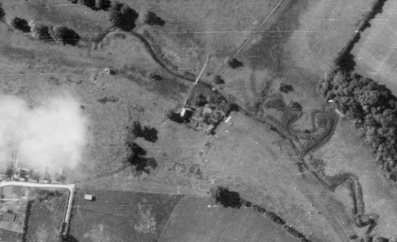
The black & white aerial photo taken in 1946 (Picture 27, part of) shows the cottage and layout of the area in general. The colour photo shows the site as it is now, part of the golf course. Victor’s narrative starts from his back garden which backed onto the brook. The Yew tree to which he refers is shown clearly in the black and white picture and a trimmed down version in the colour.
“Under the Yew tree was a large depression, which, as it was full of rubbish, I had always taken to be the rubbish tip used by past tenants of the cottage. Although it had been used as a rubbish dump, that was not its true purpose. The old man (name unknown who had visited him) said that what it really was, was an old mill pool, which I learned later was called a tail race, carved out by the spent water from a water mill. A ‘Tucking Mill,’ he told me before he left.”

Picture 37. Tuckmill Cottage. Photo courtesy of Christopher Thomas, nephew of Victor Paget

Picture 38. A sketch of the East side of Tuckmill Cottage - artist unknown
Victor’s narrative continued; “There was a mass of tumbled stone lying around the brook which it seemed fairly obvious had been some kind of structure. Most of the stone lay some seven or eight feet from the twelve inch thick garden wall on the East side of the cottage. This wall was some thirty feet long and at the end of it built at right angles to and pointing west was another short wall ten feet long and eighteen inches thick. Four feet away from this wall on the brook bank lay another pile of fallen masonry.
Most of this stone, though, lay heaped around two walls built into the bed of the brook facing East and West and some eight feet long by eighteen inches thick and four feet high. This fallen stone also lay to the North of the brook and was more or less in line with the short garden wall.
As my first task, I cleared out the tail race and at the western end of this I uncovered a channel, easily discernable by the different coloured grass that grew from it, leading in a gentle slope down to the waters of the brook. On the eastern side of the pool was another deep but muddy cutting that presented itself to me as a mill race, the channel in which the mill wheel turned.
Edging this was the first pile of stones, which, no doubt, would have been at one time another wall similar to the garden wall and on which the wheel’s axle had been supported.
My next discovery was purely accidental. Three of my daughters, school girls, one day heaped some of the fallen stone between the two thick walls, confining the brook, thus creating a dam which held the waters of the brook back. This water in due course created a large pool which the girls found deep enough to swim in.
The far bank of the brook on its South side was high enough to contain this water so as it built up and spread, it flowed over the shallow North bank and finished up by becoming a pool some eighteen feet wide. This, I concluded, must have been how the dam had been created some centuries ago.
The tumbled stone I thought was the remnants of two piers which had been built in front of the existing walls with a space between them to take the heavy oak planks which could have been put in or taken out as required to control the amount of water in the head.
About eight or nine feet away from the dam, towards the North lay some more stone. If my deductions were right, there had to be somewhere close by, a gully or sluice that would release the dammed up water onto the water wheel.

Picture 39. Tuckmill Cottage site centre showing the cottage and garden layout.
Courtesy of English Heritage (NMR) RAF photography.
Ref: RAF/106G/UK/1561. Frame 3353. 7 June, 1946

Picture 40. The site of Tuckmill, now a natural hazard on a Golf course
So I dug across the path and eventually uncovered a stone-lined channel dead in line with where the wheel would have been. I think this water was dammed much the same as the main dam though not so big or heavy, the fallen stones to me being the material from which it had been built.
Finally, there had to be within the garden area a hard floor of some kind. With the wealth of water the fullers needed, an earthen floor would have become a morass in a very short time. The obvious place for this floor was close to the water wheel and so in the rectangle formed by the cottage wall, the garden wall and the wall which supported the water wheel I progged around with my fork.
I found what I was looking for some twelve inches under the soil. A stone floor, or most of it. The stones had been sunk into the earth edgewise and covered an area of about twenty five feet by ten feet and were smooth and polished by the treading of countless feet. So although I might have been wrong in some minor detail, in the main my deductions were correct.”
Victor’s final words on his beloved cottage after he vacated it; “The building was immediately bolted, barred and sealed up. The most horrible thing about it was that it didn’t get sold for another ten years. Added to that was the fact that vandals broke into the cottage and in 1972/3 set fire to it.
The ruins of Tuck Mill and the surrounding land was bought in the early 1980’s by a gentleman who laid out the whole area as an extension to his golf course. Originally, the cottage was going to be rebuilt and I spent a deal of time with the businessman concerned, telling him its history as I knew it and describing the interior and exterior of the cottage.
The restoration of the cottage never took place though. Instead, the ruins of the cottage, its containing walls and every other piece of the stone has been bulldozed down and covered with soil and unless you knew where it had stood it would not be recognised for what it once was, a very ancient Fulling Mill."’

Picture 41. Tuckmill Cottage from the West side. Courtesy of Christopher Thomas, Nephew of Victor Paget. The water-colour is possibly by one of Victor's daughters.

Picture 42. A sketch of the West side of Tuckmill Cottage - artist unknown
It is quite easy to sense the anguish in Victor’s words, and although I cannot share his views about how ancient the site is, I am very grateful to him for recording his findings. Due to his curiosity some 40 years ago, it should be possible to conduct archaeological excavations in a bid to determine Tuckmill’s origins. Although the site may have been levelled off, the lower layers will be undisturbed. Maybe soon we can make the arrangements to open up some exploratory trenches.
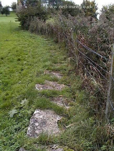
Before we leave Tuckmill it may be as well to draw attention to the trackway on the south side. (Picture 43). Now well hidden by overburden, the trackway consists of numerous sarsen stone blocks, some quite small as they start the approach from Shrivenham, extending to huge as they near the brook. Although I have no documentary evidence, it has been suggested that these stepping stones were paid for by one of the Lady Barringtons.

Picture 43. The huge Stepping Stones now mostly covered over.

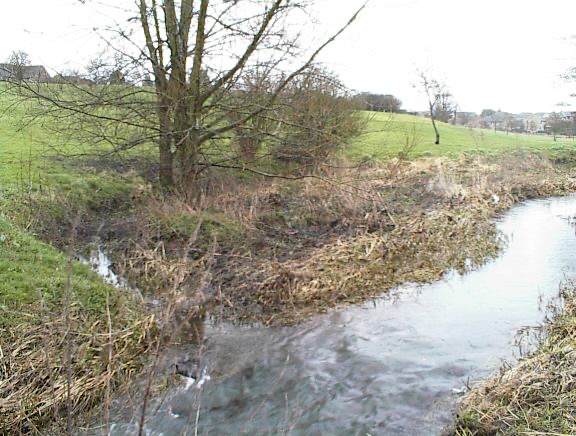
Picture 44. The Mill Pond caused by the water backing up when the sluice at the dam is in place.

Illustration by Alec Chambers of Tuckmill based on evidence from the Willington Map and Victor Paget's notes. But we now know that there was an entire farm here occupied by the Fairthorne family.

Beautiful water-colour by an artist unknown